 |
|
|||||||||||||||||||||||||||||||||||||||||||||||||||||||||||||||||||||||||||||||
|
||||||||||||||||||||||||||||||||||||||||||||||||||||||||||||||||||||||||||||||||
|
|
||||||||||||||||||||||||||||||||||||||||||||||||||||||||||||||||||||||||||||||||
|
||||||||||||||||||||||||||||||||||||||||||||||||||||||||||||||||||||||||||||||||
|
This walk follows the coast north from Eyemouth to the delightful fishing village of St. Abbs. The birdlife is excellent and varied and there is always the attraction of the restless sea to the east. This route starts in Eyemouth, which is the main fishing port on the Berwickshire Coast and is always alive with the hustle and bustle of boats. It is worthwhile spending sometime exploring Eyemouth, but once you're ready to start the walk head for the promenade, which over looks the beach, Eyemouth bay and the entrance to the harbour. At the northern end of the beach there are a set of steps, up which you'll gain access to the cliff top path. The path then follows the perimeter of a caravan park. To the opposite side of this park are the remains of Eyemouth Fort which dates from the 16th century.
The path then follows the cliff top, before descending down a dean to Linkim Shore. The path emerges onto Linkim shore near the mouth of the Abbey Burn. On the cliff nearby are metal target boards uses once as part of a shooting range. The path then follows the foreshore, before another climb to the cliff top, at the Northern end of this beach. The path continues along the cliff tops before descending by a flight of steps down to Milldown Shore. After a short walk across this stony beach and negotiating the stepping-stones over Milldown burn, the path climbs again. The path then decends gentle around the dome shaped hill know as the Homeli Known before arriving at Coldingham bay. This is a beutiful broad stretch of sand, over looked by white painted victorian villas and multicoloured beach huts. To the north of the sands the path, for the last time, again climbs by steps to the cliff top. The path then winds it's way along the cliff-top path to the quaint fishing village of St. Abbs. The walk can be extended by continuing on to St. Abbs Head. The headland is a Nature Reserve, managed by the National Trust for Scotland, and is noted for its magnificent birdlife. There is an interpretation centre (dedicated to the Nature Reserve), coffee shop, gallery and candle makers at Northfield farm. Images produced from the Ordnance Survey Get-a-map service. Images reproduced with kind permission of Ordnance Survey and Ordnance Survey of Northern Ireland.
|
|
||||||||||||||||||||||||||||||||||||||||||||||||||||||||||||||||||||||||||||||
|
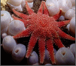
St. Abbs & Eyemouth Voluntary Marine Reserve. |
||||||||||||||||||||||||||||||||||||||||||||||||||||||||||||||||||||||||||||||||